
For navigation, instrument repeater, log keeping, Internet, weather, banking and music.
Over the last few seasons the sounder and log were replaced with Raymarine ST40 Bidata, and I added an ST40 digital wind instrument, to a Garmin 128 and Simrad TP20 autopilot all mounted in the cockpit. Wishing for repeaters at the nav table but with little room, I have connected them all via a Seatalk/NMEA interface to a cheap secondhand laptop but of good quality, a Toshiba Tecra 8000, running at 400Mhz with 128Mb ram.
What brings all this together on the screen is nav software called Tsunami99, already you are thinking “thats out of date”, read on.
Having just read the article in Sailing Today Feb 06 with a group test on cartography from UKHO, Bluechart, C-Map NT+, Navionics Gold, C-MapNT Max and Navionics Platinum. Maptech I think provide the Navionics charts that Raymarine use. Tsunami99 still beats them for the huge array of abilities and utilities it has. But I say this without experience of them except the trial software from Maptech.
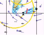
One of the main complaints the author made was a lack of route planning using the tidal and stream data. I find this an extremely useful utility, Tsunami99 easily tells me the best time of day and best day of the week to cast off in order to make the tidal gate at the Lizard and arrive in day light at Porth Cressa. Firstly, I can scroll through the hours and watch the currents change direction and rate to find out the min and max ETA at the gate, it also brings to my attention the currents around Wolf rock which turn 360 degrees in 12 hours.
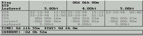
Then in the passage plan enter the average log speed for each hour, increasing or decreasing the start time by half an hour to find the best arrival time verses tidal gate. It can take 5 mins, or an hour as I leisurely contemplate the options. To summarize, I plot the course and waypoints on the paper chart first then transfer the waypoints to the software then upload to the GPS. This method double checks and negates the possibility of inputting the wrong figure into the GPS which the GPS/myself is prone to, due to scrolling through A-Z and 1-9 for every single digit.
It is possible to vary the calculations performed. If for example you know the time at which you must arrive at a particular WP, instead of entering the estimated speed, you can enter the ETA and the software will calculate the speed which must be achieved. Showing the net effect of the current.
Aarh but, who is sad enough to want to faf with a computer while sailing?
Well I don't....I spend 10 mins plugging in and uploading the waypoints to the GPS in the cockpit, I just switch it on and click the Tsunami99 icon as I leave Plymouth Sound (thats all) and leave it running, set to keep a half hour log recording all the data from the instruments. I still have the paper chart out and mark my position, recording pressure every hour and take hand bearing fixes when I can.
As skipper my 4 hours off watch used to be spent dozing for 55 mins in the hour, between position marking, checking the heading, the crew etc...Now I have no need to leave my bunk, just open an eye and check the night screen readout delegating the rest to the watchkeeper. I'm still on call for shipping etc...On arrival it's drop anchor and switch off.
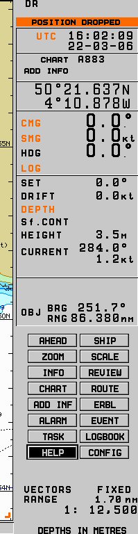
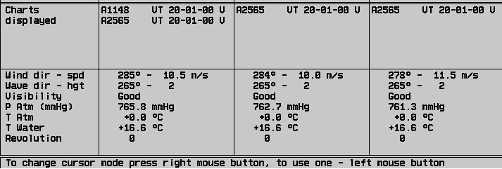
Here is a cut section of the log.
It scrolls down to this page below
OK how about the power drain ? My old instruments, navlights and VHF used to flatten
a 135 amp battery by about 04.00.
The new instruments, LED nav lights and VHF use:
| DAY TIME (max) | DAY (min) | NIGHT TIME (max) | NIGHT (min) | ||
|
ST40 Bidata ST40 Wind GPS Garmin 128 TP20 A/Pilot Icom 401 VHF Laptop Laptop PSU ----- ----- -------------- TOTAL |
35ma 25ma 166ma 500ma 120ma 2.4A 250ma ----- ----- -------------- 3.496 Amps |
35ma 25ma 166ma ----- 120ma ----- ----- ----- ----- -------------- 346ma |
ST40 Bidata ST40 Wind GPS Garmin 128 TP20 A/Pilot Icom 401 VHF Laptop Laptop PSU Compass Trilight ---------------- TOTAL |
35ma 25ma 166ma 500ma 120ma 2.4A 250ma 60ma 300ma ----------------- 3.856 Amps |
35ma 25ma 166ma ----- 120ma ----- ----- 60ma 300ma ----------------- 706 ma |
The maximum amounts to 23 Amps in 6 hours. So now with the laptop I need to run the engine with a 60Amp alternator for an hour at 06.30, plus an hour before dark for a full charge, having sailed 24 hours. Anyway it's not unusual to start the engine to cross shipping or to make a tidal gate in light winds. I can improve on that by setting the screen to switch off after 5mins inactivity and using a slower processor speed and dimmer screen in the battery saving function, although I have to turn off the screensaver. The engine has its own battery, the laptop is protected from power spikes by the 12v to 15v regulated power adapter and is not effected by starting. If I have a sudden power failure all is not lost as Tsunami saves the data every few minutes.
The other benefits of Tsunami99 include:
- Measuring Ranges and Bearings quickly
- Controlling Chart loading and filtering chart detail
- Controlling, viewing and adding comments to the Logbook
- Configuration - Customising the System
- Advanced Functions
- Choice of 55 different Alarms (visual and/or audio).
- Tidal Heights (real time with on chart bars at ports).
- Tidal Stream & Surface Current on the chart.
- Route Checking (for rocks and dangers).
- Port Information (indepth info, add your own ports/info).
- Wind Calculations (copy details off the screen or project your own).
- Passage Planning with effect of Tides and Currents.
- Connecting 1 or 2 GPS Receivers.
- Utilities System Setup (including NMEA trace utility, listing all messages in the NMEA wire).
- Chart Catalogue (all worlds charts, just email or phone for permit code).
- Search and Rescue (choice of 3 search patterns enter start position, speed and leeway).
- Navtex Receiver (needs receiver with NMEA output).
- Navtex Viewer (sorts and stores info by position and displays areas on chart with info symbol, automatically deletes cancelled data).
- Playback (watch your trip at home).
- Tides (optionally integrated panel that can print out).
- Print out the route, passage info, tides, log and screen.
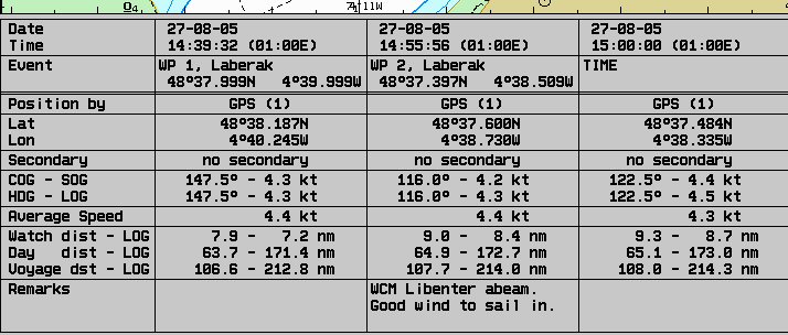
The best utility is adding your own chart corrections of bouys, symbols, or just add notes. So I can quickly correct the charts without having to buy updates. The 6 display settings use different colours to suit the cabin light. Night inverted is good for reading without destroying my nightsight. Everything is controlled by curser with left or right clicks, I have a trackball. Windows and other programs are still accessible through the 'windows key' or 'crtl + escape' for the start button.
As I said before I just switch on and switch off. If I take a side trip without an electronic route plotted, ie, a paper chart route, I still switch on for the logging all the instrument data. The log and track is saved for reviewing later.
After 2 months cruising I have an A4 colour picture with the complete trip from Plymouth to the Scillies to the Channel Islands both sides of the channel. Although in the Morlaix river we appear to have crossed the land, that doesn't sound too good but between the rocks at Treburden and into Paimpol the chart was fine.
Enough of that what else ? A wireless network card to pickup weather charts and reports in the marina, send email and update the family and make payments and control my bank accounts. The infrared connects to my mobile's modem so at anchor I can do the same albeit brief due to cost. There is enough music on the harddrive to last the cruise which uses less power than using the CD drive.
Equipment used:
- Raymarine Seatalk/NMEA interface. £90
- Data panel socket/plug and screened data cable with RS232 D Type, serial 9 pin plug (for the computer) there are just 3 wires.
- Laptop PSU regulated adaptor 15/16/18/19/20/22/24v DC with numerus plugs, from Maplins.(code L40BB)£30
- I made a webbing harness for the laptop from 25m/m webbing, velcro and plastic clip buckles. £12
- A Trackball instead of a mouse that doesn't roll about.
Equipment wanted:
- Navtex with NMEA output for Tsunami99 to log and sort the data.
Useful websites:
www.maplin.co.uk/
www.transasusa.com/ (Latest Nav software from the Tsunami99 makers)
www.raymarine.com/
www.icomeurope.com/
www.ultraleds.co.uk/ (Replace your bulbs
with purpose made leds. Festoon etc)
www.imray.com/ (Notices to mariners)
Finally, I was amazed when I first connected the instruments and GPS to the nav software the default settings all worked, except for one mistake the input and output wires from the GPS go to the output and input of the data interface, one naturally assumes that brown connects to brown, no it's brown to blue.
I can now sail to the fluxgate compass in the autopilot, or sail to the GPS, or sail to the wind instrument, or sail to the PC. I managed to impress and confuse the watch when tapping the wrong key inside and going about we headed 100 degrees off course! So I no longer faf with it while underway, unless I want some fun and shout “ready about, lee ho”, from the cabin.
If anyone would like to see the Tsunami99 User Manual a 1Mb .pdf file I can email it or upload it somewhere, contact me
May your wind blow, with curt sails and a stiff boat.
Sandy Niemeyer (Blue Fin)